
Future competition in the drone industry: a dual game of technological system and ecological construction, with six core technologies and four hidden lines to seize the opportunity of low altitude economy
As the low altitude economy enters the eve of its outbreak, the competition in the drone industry has long transcended the limitations of "single technology competition" and evolved into a dual game of deep construction of technological systems and ecological closed-loop capabilities. If top enterprises want to take the initiative, they need to anchor the three core strategies of "technology positioning, standard setting, and scenario closure", break through the boundaries of "hard power" in the six core technology dimensions, and crack the "scale based compliance code" in the four hidden areas, in order to stand firm in the trillion dollar market.
1、 Six core technologies: Reshaping the "hard power" of drones, breaking through performance and scene boundaries
The competition for "hard power" of drones focuses on "smarter, more reliable, and more versatile", with six core technologies addressing core pain points such as complex environment adaptation, long endurance, and multi scenario applications from the dimensions of "brain, perception, communication, power, payload, and safety"
1. AI Brain: Elevating Drones from 'Execution Tools' to' Autonomous Decision Makers'
Dynamic path planning: Real time perception of urban canyons, forest canopy closure, and sudden obstacles (such as temporary construction areas), dynamically adjusting the optimal route like a human pilot, avoiding the rigidity problem of traditional "fixed routes";
Intelligent scene recognition: not only can it achieve basic obstacle avoidance, but it can also accurately distinguish obstacle types (such as pedestrians/vehicles/high-voltage power lines), and even identify crop pests and soil moisture in agricultural scenes, directly outputting "pesticide/fertilization plans";
Cluster collaborative combat: Thousands of drones can autonomously form like a flock of birds without the need for a central control system, synchronously completing complex tasks such as large-scale mapping, forest fire search and rescue, and large-scale event light shows, with efficiency increased by more than 50 times compared to single aircraft operations.
2. Perception Navigation: Creating an "all-weather perception system" for drones, bidding farewell to "inability to see or find"
Multi sensor fusion: integrating visual cameras, laser radar, millimeter wave radar, and ultrasonic sensors to achieve 360 ° blind spot perception - resistant to water mist interference in rainy days and accurate positioning even without satellite signals in tunnels, solving the problem of "blindness in extreme environments";
Anti interference positioning technology: integrating Beidou GPS、 The Galileo multi satellite system, combined with ground base stations to compensate for blind spots, can maintain sub meter positioning accuracy even in signal blocking areas of urban high-rise buildings, avoiding "drifting out of control";
Biomimetic perception black technology: drawing on the principle of bat echolocation to develop low-power ultrasonic navigation (reducing power consumption by 70%, suitable for micro drones), imitating fruit fly compound eyes to design optical flow sensors, and achieving stable hovering in indoor and other unmanned satellite scenes.
3. Communication upgrade: Build a "neural network" for drones to achieve "beyond line of sight and no loss of contact"
5G/6G low latency communication: beyond line of sight control delay compressed to within 20 milliseconds, capable of real-time transmission of 8K high-definition images, providing "real-time response" capability for urban drone logistics (such as fresh food delivery) and air traffic control;
Satellite communication empowerment: Equipped with lightweight satellite terminals, it can maintain communication even in "no ground signal areas" such as ocean transportation and cross provincial power inspections, truly achieving "global coverage without blind spots";
Security encryption protection: using frequency hopping communication technology to prevent signal interference, combined with blockchain to store flight data, to eliminate the risk of "black flying" tampering with flight routes and stealing mission data, meeting the security needs of government and enterprise levels.
4. Power Innovation: Cracking the Pain Points of "Short Range and Slow Energy Replenishment" and Expanding Application Scenarios
Solid state battery technology: energy density exceeds 400Wh/kg, with a 50% increase in endurance compared to traditional lithium batteries - the single flight time of logistics drones has been extended from 1.5 hours to 2.5 hours, covering a 50 kilometer radius for distribution;
Hydrogen electric hybrid power: Equipped with a hydrogen fuel cell and an electric rotor, it has a range of up to 8 hours and modular hydrogen exchange only takes 3 minutes (10 times faster than charging), making it particularly suitable for medical emergencies (such as organ transportation) and long endurance inspection scenarios;
Solar powered high-altitude aircraft: The body is covered with high-efficiency photovoltaic panels, and the high-altitude long endurance aircraft can fly continuously for several months, becoming an "aerial base station" to solve the communication coverage problem in remote mountainous areas and islands.
5. Load and Platform: Creating a "plug and play" all-in-one platform that adapts to the needs of multiple scenarios
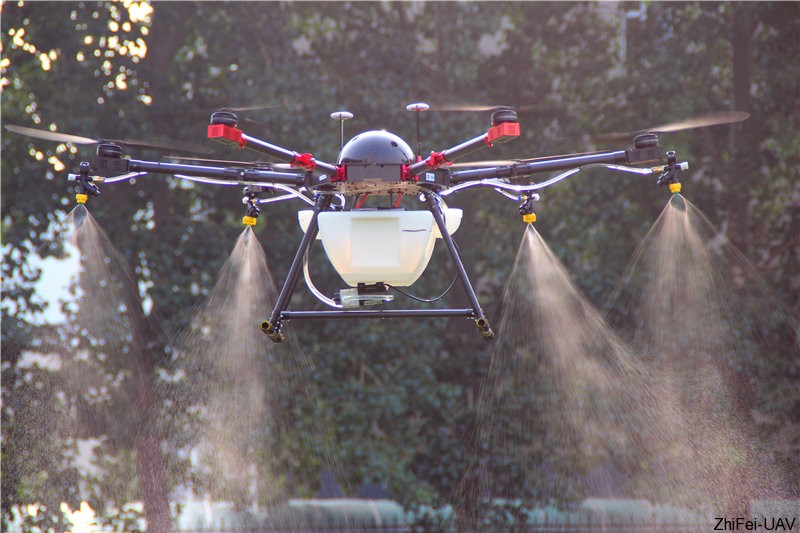
Modular payload design: Multi spectral cameras, gas sensors, and material throwing devices can be replaced in 2 minutes - the same drone can be used for agricultural crop protection in the morning, environmental monitoring in the afternoon, and emergency search and rescue in the evening, increasing equipment utilization by 3 times;
Biomimetic platform optimization: bird like folding wing design reduces wind resistance and increases flight efficiency by 20%; The vertical takeoff and landing fixed wing aircraft model combines the flexibility of helicopters with the long endurance of fixed wings, making it the preferred choice for industrial inspections such as oil and gas pipeline inspections;
Mobile takeoff and landing support: The vehicle mounted unmanned aerial vehicle takeoff and landing platform can be quickly deployed in 30 minutes, equipped with emergency power supply, and can "leave at will" in outdoor rescue, temporary communication in earthquake stricken areas, and other scenarios, without relying on fixed airports.

6. Safe and reliable: Build a "double insurance" to ensure that drones fly steadily and follow rules
Fault redundancy design: Even if two motors fail, the multi rotor drone can still land safely with the remaining motor power; The flight control system is equipped with triple sensor backup to avoid crashes caused by "single point of failure";
Breakthrough in Airworthiness Certification: Transforming AI decision logic into a human readable "decision tree" that meets the stringent airworthiness standards of the Civil Aviation Administration of China; Simulate one billion fault scenarios (such as extreme weather and electromagnetic interference) through digital twin technology to optimize safety strategies in advance;
Ethics and privacy protection: Built in "sensitive area recognition" function, automatically reduces shooting resolution when approaching schools or military areas; Privacy data such as facial expressions and license plates are anonymized locally on the device, and only hash values are uploaded, in compliance with GDPR and domestic Personal Information Protection Law requirements.
2、 Four major dark line technologies: cracking the large-scale "compliance code" and bridging the last mile from technology to implementation
If the core technology is "hard power", the four major dark line technologies are "soft support" - solving key challenges such as airspace control, operational efficiency, social acceptance, and data reliability for large-scale implementation:
1. Digitalization of airspace: issuing "digital ID cards" to drones to prevent "black flying"
EID digital license plate: Each drone is implanted with an tamper proof chip based "digital ID card" that records body information, operator qualifications, and flight permissions. Once entering a no fly zone, the "lock up" function can be remotely triggered;
Dynamic geofencing: Based on real-time updated airspace control data, temporary control areas (such as major events and fire scenes) are pushed to the drone flight control system in seconds, automatically avoiding without manual intervention and reducing the risk of "human violations".
2. Low altitude economic operation platform: Creating an "App Store" for drones to lower application barriers
Task level API market: Small and medium-sized enterprises do not need to build their own drone teams, and can "pay per use call drone services" (such as calling crop protection drones to operate 100 acres of farmland) through API interfaces, reducing technical costs by 90%;
Intelligent scheduling engine: automatically matches task requirements (such as "delivering 5 kilograms of medical supplies within 30 minutes") with drone performance (range, load capacity), optimizes resource allocation like Uber schedules vehicles, and increases drone asset utilization to over 90%.
3. Privacy and noise control: Obtain the "City Flight Social Permit" to avoid disputes over "disturbing the public"
Low noise design: The biomimetic serrated blade reduces noise by 3 decibels, combined with urban noise maps, automatically avoids nighttime routes in residential areas, and solves the problem of "drone disturbance" complaints;
Privacy computing payload: After the task is completed, the face and license plate data stored in the device are automatically erased, and only the desensitized feature information (such as "regional personnel density" rather than specific faces) is returned, balancing task requirements and privacy protection.
4. Blockchain flying ledger: making data "trustworthy and traceable", solving the problem of collaborative trust
Full process data storage: Record every takeoff and landing time, flight trajectory, energy consumption data, and task results, providing an immutable data source for insurance claims (such as drone crash damage assessment) and tax accounting for airspace use;
Multi party real-time audit: Logistics companies, regulatory authorities, and insurance companies can view flight data in real time, resolve disputes over task completion and differences in premium accounting, and connect the low altitude economic synergy chain.
3、 Future outlook: From "single device" to "aerial intelligent node", low altitude economy enters the trillion yuan era
Key breakthroughs from 2025 to 2030
Communication interconnection: Combining 6G technology with terahertz communication, achieving integrated connection of unmanned aerial vehicles with satellites, ground base stations, and other aircraft in the air, space, and sea, with no blind spots covered;
Material Innovation: The self-healing body material can automatically fill small cracks and cope with extreme environments such as high altitude, low temperature, and sandstorms;
Positioning accuracy: The anti-interference ability of quantum navigation technology has been further upgraded, and the positioning accuracy has reached sub meter level, meeting the strict requirements of urban air traffic (UAM).
Ultimate goal: to integrate into production and daily life as an "aerial intelligent node"
In the future, drones will no longer be isolated devices, but will become "aerial intelligent nodes" in fields such as agriculture, logistics, security, and healthcare. For example, in agricultural scenarios, drones can not only complete crop protection, but also link ground sensors and satellite data to generate "crop growth reports"; In the logistics scenario, drones, express cabinets, and unmanned vehicles form a closed loop of "air ground intermodal transportation", truly promoting the scale of low altitude economy to exceed one trillion yuan.
4、 The 'Four Dimensional War' of Leading Enterprises: Collaborative Evolution of Technology, Standards, Scenarios, and Ecology
The current top enterprises have upgraded from "single technology breakthrough" to a four-dimensional competition of "technology standard scenario ecology", each establishing a moat in a segmented track:
DJI: Vertically integrating "hardware (drones)+algorithms (flight control systems)+cloud platforms (DJI agricultural services/DJI Sikong)" to monopolize the consumer market, while accumulating agricultural scene data and optimizing AI recognition algorithms in reverse;
Zipline: Focusing on medical logistics, building a closed-loop ecosystem of "drones+ground distribution stations+airworthiness certification", becoming the world's first drone logistics enterprise to obtain the Civil Aviation Administration's "normalized operation license";
Yihang Intelligence: betting on the manned drone track, innovating through the scenario of "manned spacecraft+urban air traffic (UAM) planning", and taking the lead in achieving manned flight pilot in Guangzhou and Dubai;
Tiantu: Deeply cultivating the integration of industry and education through "cloud control platform+AI training+education and training system", exporting certified pilots to the industry, and mastering airspace operation data through cloud control system, forming an ecological barrier of "technology talent operation".
Summary: During the critical period of low altitude economy, the dual drivers of "technology+ecology" win the future
The next three years will be a key window for the "technology scale landing" of the drone industry - relying solely on a single technological breakthrough (such as range improvement) is no longer enough to form barriers. Only by laying out cutting-edge technologies such as quantum navigation and biosynthetic materials in advance, and building an ecosystem of "airspace operation, airworthiness standards, and scene closed-loop" enterprises, can they dominate the final pattern in the trillion level low altitude economy market. The competition of drones is essentially a collaborative war of "hard technology breaking through performance boundaries and soft ecology determining landing speed".