
1. Introduction
Unmanned Aerial Vehicles (UAVs), as a type of aircraft that does not require human piloting, have shown tremendous potential and value in many fields such as military, civilian, and scientific research in recent years. With the continuous advancement of technology, drone technology has evolved from simple flight models to highly complex and multifunctional intelligent flight systems. Its emergence not only changed the traditional mode of aviation operations, but also brought new perspectives and solutions to people, and had a profound impact on social development.
2、 The Development History of Drones
(1) Early exploration stage
The history of drones can be traced back to the early 20th century. At that time, military demand propelled the emergence of drone technology. During World War I, people began to attempt the development of unmanned aerial vehicles for military reconnaissance and other purposes. These early unmanned aerial vehicles had simple designs and limited flight performance, but they laid the foundation for subsequent development. For example, the "Queen Bee" drone developed by the UK in the 1930s was the world's first practical radio controlled target drone, providing an important simulation target for testing anti-aircraft weapons.
(2) Military application expansion stage
During World War II and the post-war period, drone technology further developed in the military field. Countries are beginning to use drones for more complex military tasks, such as intelligence gathering, electronic warfare, and attacks. In the Vietnam War, the United States used a large number of drones for reconnaissance, providing critical intelligence support for combat operations. During this period, drones have made significant improvements in flight performance, payload capacity, and remote control technology, gradually becoming an important component of military strategy and tactics.
(3) The Rise of Civil Field and Modern Development Stage
With the end of the Cold War, the relative decrease in military demand, and the rapid development of related fields such as electronic technology and materials science, drone technology began to penetrate into the civilian sector. At the end of the 20th century and the beginning of the 21st century, drones demonstrated unique advantages in civilian fields such as aerial photography, agricultural crop protection, power inspection, and environmental monitoring, and the market demand continued to grow. At the same time, modern drones have made breakthrough progress in intelligence, miniaturization, and long endurance. For example, a series of high-performance civilian drone products launched by companies such as DJI have greatly promoted the popularization and application of drone technology worldwide.
3、 Classification of unmanned aerial vehicles
(1) Classified by flight platform configuration
Fixed wing unmanned aerial vehicle
Fixed wing unmanned aerial vehicles have the characteristic of fixed wings, and their flight principle is similar to traditional aircraft, generating lift through the difference in airflow velocity between the upper and lower surfaces of the wings. This type of drone has fast flight speed, long range, and large payload, making it suitable for large-scale aerial surveying, border patrol, and other tasks. For example, some fixed wing unmanned aerial vehicles used for long-distance ocean monitoring can cover a large area of sea in one flight, conducting reconnaissance and monitoring of maritime targets.
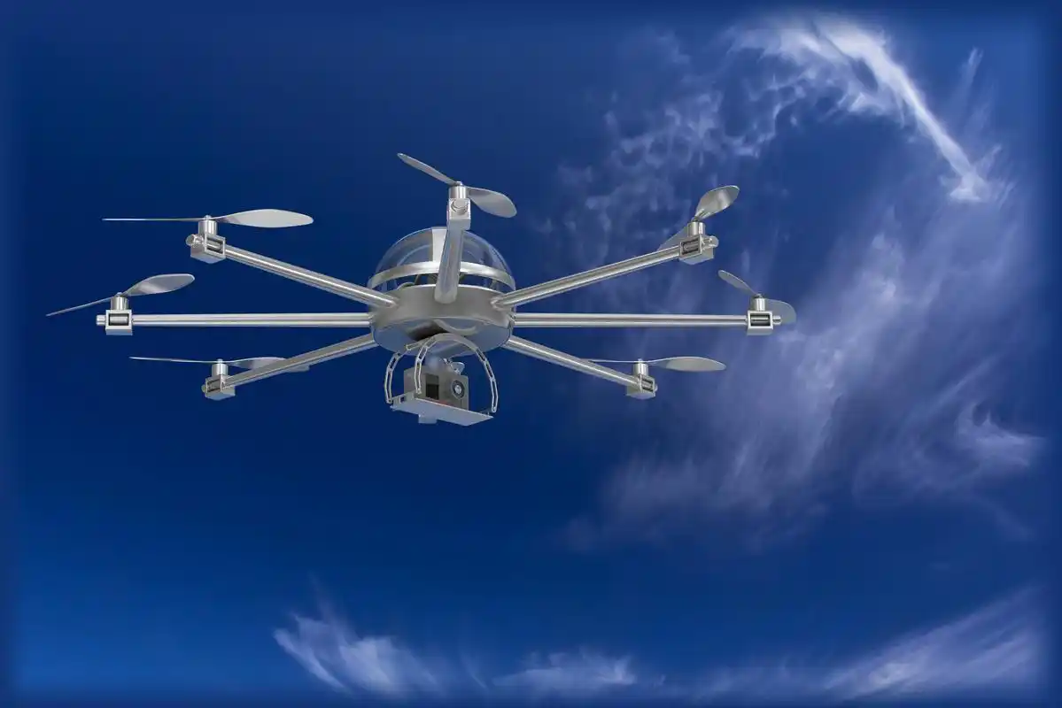
rotor drone
Rotorcraft drones are currently the most widely used type of drone, including single rotor helicopters and multi rotor drones (such as quadcopters, hexacopters, octacopters, etc.). Multi rotor unmanned aerial vehicles generate lift and control flight attitude through the rotation of multiple rotors. It has the advantages of simple structure, flexible operation, and the ability to take off and land vertically. It can fly in small spaces and is commonly used for tasks that require low altitude operations and high maneuverability, such as aerial photography, logistics distribution, and power inspection. Single wing helicopter drones have certain advantages in payload capacity and flight stability, and are commonly used in some special industrial applications.
unmanned airship
Unmanned airship is a type of aircraft that is lighter than air. It generates buoyancy by filling it with a lighter gas such as helium, and then combines it with a power system to achieve flight. Unmanned airships have the characteristics of long hovering time and high payload capacity, making them suitable for long-term atmospheric monitoring, communication relay and other tasks. However, its flight speed is slow and it is sensitive to meteorological conditions.
Flapping wing unmanned aerial vehicle
Flapping wing drones mimic the flight patterns of birds or insects, generating lift and thrust through the flapping of their wings. This type of drone has unique advantages in flight efficiency and maneuverability, but due to the complexity of its mechanical structure and flight control, it is still in the research and experimental stage and has not yet been widely applied. However, flapping wing drones have potential applications in fields such as military reconnaissance concealment and biological research.
(2) Classified by purpose
Military drones
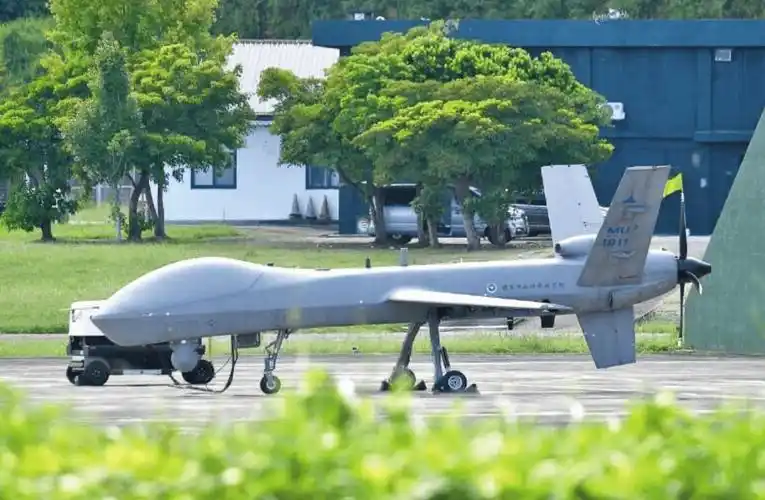
Military drones can be divided into reconnaissance drones, attack drones, target drones, etc. Reconnaissance drones are used to obtain enemy intelligence and are equipped with advanced optical, infrared, radar and other reconnaissance equipment, which can monitor target areas without being detected. Attacking drones carries weapons and ammunition, allowing for precise strikes on enemy targets, such as the US Predator series of attack drones. Target drones are used to simulate enemy aircraft or missiles and provide targets for the training and testing of air defense weapon systems.
civil drone
Aerial photography and film production drones: These drones are equipped with high-quality cameras or camcorders that can capture high-resolution, multi angle images, providing unique shooting perspectives for film and television production, advertising shooting, news reporting, and more. For example, in movie shooting, drones can capture grand scenes and thrilling shots that were previously difficult to achieve.
Agricultural crop protection drones: Agricultural crop protection drones can carry pesticides or fertilizers, fly at low altitude above farmland, and evenly spray pesticides or fertilizers on crops through special spraying systems. Compared with traditional manual spraying, crop protection drones have higher efficiency, more uniform spraying, and can avoid potential damage to crops caused by manual operations.
Electric power inspection drone: used for inspecting power lines and equipment. It can be equipped with visible light cameras, infrared thermal imaging devices and other equipment to inspect the insulators, wires, towers and other components of power transmission lines, timely detect potential faults and hidden dangers, such as insulator damage, wire heating and other problems, greatly improving the efficiency and safety of power inspection.
Logistics distribution drones: In the logistics field, drones can achieve short distance cargo distribution, especially in areas with inconvenient transportation or emergency rescue material distribution, with great potential for application. Some companies are developing logistics drones that can automatically navigate and deliver accurately, with the potential to change traditional logistics and distribution models.

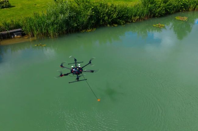
Environmental monitoring drones: can be used in environmental fields such as air pollution monitoring, water quality monitoring, forest resource monitoring, etc. For example, drones equipped with gas sensors can collect atmospheric samples at different altitudes to analyze pollutant concentrations and distribution; In forest resource monitoring, drones can quickly obtain image information of large areas of forests for evaluating forest coverage, tree growth status, and other factors.
Research drone
Research drones play an important role in fields such as meteorology, geological exploration, and oceanography. In meteorological research, drones can carry meteorological detection instruments into the clouds to obtain more accurate meteorological data, which helps improve the accuracy of weather forecasts. In terms of geological exploration, drones can use high-resolution imaging technology to conduct detailed surveys of terrain and landforms, providing data support for geological hazard prediction and mineral resource exploration. In oceanographic research, drones can fly above the sea surface to monitor parameters such as ocean surface temperature, salinity, and wave height, providing a basis for marine environment research and marine resource development.
4、 The basic structure and working principle of unmanned aerial vehicles
(1) Basic structure
fuselage
The fuselage is the main structure of a drone, providing support and protection for other components. The design of the fuselage needs to consider factors such as strength, weight, and aerodynamics, and usually uses lightweight and high-strength materials such as carbon fiber, aluminum alloy, etc. The body structure of different types of drones varies, with fixed wing drones having streamlined bodies to reduce air resistance; The fuselage of a rotary wing drone is mainly a frame structure that accommodates components such as batteries and flight control systems.
power system
Engines (for fixed wing drones and some large rotary wing drones): Common engines for fixed wing drones include piston engines, turboprop engines, turbojet engines, etc. The piston engine has a simple structure and low cost, making it suitable for small fixed wing unmanned aerial vehicles; Turboprop engines have high power and can be used for medium-sized fixed wing unmanned aerial vehicles; Turbojet engines are suitable for large unmanned aerial vehicles flying at high speeds and altitudes. For some large rotary wing drones, turboshaft engines may also be used to provide power.
Electric motor (for small rotary wing drones): Small rotary wing drones typically use electric motors as their power source. Electric motors have the advantages of simple structure, fast response speed, easy control, and convenient power source, which can be powered by batteries. Meanwhile, the speed of the electric motor can be precisely controlled through an electronic governor, providing convenience for the flight control of unmanned aerial vehicles.
Propeller and rotor: The propeller is a critical component for generating thrust or lift in fixed wing and partially rotary wing unmanned aerial vehicles. The design parameters of a propeller include diameter, pitch, number of blades, etc., which can affect the efficiency and performance of the propeller. The rotor is a unique component of rotary wing drones, which generates lift through rotation and controls the drone's flight attitude by changing the rotor's speed and tilt angle.
flight control system
The flight control system is the core of the drone, equivalent to the "brain" of the drone. It mainly consists of sensors, controllers, and actuators. Sensors include accelerometers, gyroscopes, magnetometers, barometers, GPS, etc., which are used to obtain real-time information such as the attitude, position, and speed of unmanned aerial vehicles. The controller calculates control instructions using specific algorithms based on data collected by sensors. The actuator adjusts the flight attitude and motion of the drone according to control instructions, such as adjusting the rotor speed, controlling the angle of the control surface, etc. The flight control system can achieve autonomous flight, stable flight, and switching of various flight modes for unmanned aerial vehicles.
navigation system
The navigation system is used to determine the position and flight path of the drone. Common navigation methods include GPS navigation, inertial navigation, visual navigation, etc. GPS navigation determines the latitude, longitude, altitude and other information of drones by receiving satellite signals, which has the advantages of high positioning accuracy and global coverage. However, positioning errors may occur in the case of signal obstruction or interference. Inertial navigation utilizes sensors such as accelerometers and gyroscopes to calculate the position and attitude changes of unmanned aerial vehicles by integrating their acceleration and angular velocity, but there is a problem of error accumulation. Visual navigation uses cameras to capture images of the surrounding environment and utilizes image recognition technology and algorithms to determine the position and flight direction of drones. It has good application prospects in some complex environments and is currently often combined with other navigation methods.
communication system
The communication system is used to achieve data transmission and command reception between unmanned aerial vehicles and ground control stations. It includes a wireless communication link between the remote control and the drone, as well as a data link between the drone and the ground control station. Wireless communication links typically use radio frequency technology, such as the 2.4GHz or 5.8GHz frequency bands, to achieve remote control of drones. The data link is responsible for transmitting the flight status data, sensor data, and receiving control instructions from the ground control station of the drone, ensuring information exchange during the flight process.
(2) Working principle
Principles of Flight Attitude Control
The flight attitude control of unmanned aerial vehicles is mainly based on the processing of sensor data by the flight control system and the control of actuators. Taking a rotary wing drone as an example, when the drone needs to maintain balance or change attitude, the flight control system calculates the required speed adjustment for each rotor based on the drone attitude information detected by the accelerometer and gyroscope. For example, when the drone tilts forward, the flight control system will increase the speed of the front rotor and decrease the speed of the rear rotor to restore balance to the drone. For fixed wing unmanned aerial vehicles, the roll, pitch, and yaw attitude of the aircraft can be changed by controlling the angles of the ailerons, elevators, and rudders.
Principles of Flight Trajectory Control
Flight trajectory control is achieved through the collaborative work of navigation and flight control systems. In GPS navigation mode, the ground control station can set the flight path of the drone on the map, and this path information is transmitted to the drone's flight control system through a data link. The flight control system calculates the flight direction and speed commands based on the current position of the drone and the set target position, combined with the positioning information of the navigation system. At the same time, the flight control system will adjust the flight trajectory based on environmental changes during the flight process (such as encountering airflow disturbances) to ensure that the drone flies along the predetermined path. In autonomous flight mode, the drone can automatically complete flight tasks according to preset programs and algorithms, such as conducting aerial photography or inspection operations according to the set route.
5、 Key Technologies of Drones
(1) Flight Control Technology
Sensor Fusion Technology
Sensor fusion is the comprehensive processing of various types of sensor data to enhance the perception ability of drones towards their own state and environment. For example, by fusing data from sensors such as accelerometers, gyroscopes, magnetometers, and GPS, more accurate drone attitude, position, and velocity information can be obtained. The commonly used sensor fusion algorithms include Kalman filtering algorithm, extended Kalman filtering algorithm, etc. These algorithms can effectively handle the noise and uncertainty in sensor data, and improve the reliability of the data.
control algorithm
The control algorithm of unmanned aerial vehicles is the key to achieving stable flight and precise attitude control. Common control algorithms include PID (proportional integral derivative) control algorithm, fuzzy control algorithm, neural network control algorithm, etc. The PID control algorithm is a classic linear control algorithm that achieves stable control of drone attitude by adjusting three parameters: proportional, integral, and derivative. Fuzzy control algorithm is based on fuzzy logic, which fuzzifies the input sensors and obtains control outputs through fuzzy rule libraries and inference mechanisms. It is suitable for handling complex nonlinear systems. Neural network control algorithms utilize the learning ability of neural networks to optimize control strategies through training data, with strong adaptability and self-learning ability, but high computational complexity.

(2) Power and Energy Technology
Efficient Power System Design
In order to improve the performance of drones, it is necessary to design an efficient power system. For fixed wing unmanned aerial vehicles, optimizing the fuel efficiency of the engine and improving the propulsion efficiency of the propeller are key. In terms of engine design, adopting advanced combustion technology and lightweight design can improve the power to weight ratio of the engine. For rotary wing drones, improving the efficiency of the electric motor and optimizing the aerodynamic design of the rotor can increase lift and reduce energy consumption. For example, some new rotor designs use special blade shapes and materials that can generate greater lift at the same speed.
High performance battery technology
In small drones, batteries are the main source of energy. Therefore, high-performance battery technology is crucial for extending the endurance of drones. At present, lithium-ion batteries are widely used in the field of drones, but they are still constantly being improved. The research direction includes improving the energy density of batteries, shortening charging time, and extending battery life. In addition, new battery technologies such as lithium sulfur batteries and solid-state batteries are also under development, which are expected to provide drones with higher energy density and safer performance.
(3) Navigation and positioning technology
Multi source navigation fusion technology
In order to improve the accuracy and reliability of navigation, multi-source navigation fusion technology has become a development trend. Combining multiple navigation methods such as GPS, inertial navigation, visual navigation, and geomagnetic navigation can fully leverage their respective advantages and compensate for the shortcomings of a single navigation method. For example, in the case of GPS signal loss, inertial navigation can continue to provide short-term position and attitude information, while visual navigation can assist in positioning in complex environments, improving the navigation capability of drones in complex environments.
High precision positioning technology
In some applications that require high positioning accuracy, such as precision agriculture and logistics distribution, high-precision positioning technology is needed. In addition to traditional GPS differential positioning technology, satellite based augmentation systems (such as WAAS, EGNOS, etc.) and ground station assisted positioning technology are also constantly developing. In addition, using technologies such as visual navigation and LiDAR for relative positioning and high-precision map matching can achieve centimeter or even millimeter level positioning accuracy.
(4) Communication Technology
High bandwidth and low latency communication technology
With the expansion of drone applications, the requirements for communication bandwidth and latency are becoming increasingly high. For example, in high-definition video transmission aerial photography applications, a high bandwidth communication link is required to ensure real-time transmission of video data. Meanwhile, in some tasks that require real-time control, such as drone cluster control and precise delivery of logistics distribution drones, low latency communication is crucial. At present, the development of 5G communication technology has brought new opportunities for drone communication. The high bandwidth, low latency, and large capacity characteristics of 5G networks can meet the communication needs of drones in complex tasks.
Communication Security Technology
Due to the application of drones in key military and civilian fields, communication security issues are becoming increasingly prominent. Ensuring the security of drone communication links and preventing interference, hijacking, or information theft is crucial. Communication security technology includes encryption technology, identity authentication technology, anti-interference technology, etc. Encryption technology can encrypt communication data, preventing unauthorized users from accessing information content; Identity authentication technology can ensure the legitimacy of both parties in communication; Anti interference technology can improve the stability of communication links in complex electromagnetic environments.
6、 The current application status of unmanned aerial vehicles
(1) Current Status of Military Applications
Intelligence reconnaissance and surveillance
In modern warfare, military drones have become an important means of intelligence reconnaissance and surveillance. Various types of reconnaissance drones are widely used by military forces around the world, such as the US RQ-4 "Global Hawk" drone, which can fly at high altitudes for long periods of time and use its advanced optical, infrared, and radar reconnaissance equipment to continuously monitor large areas and obtain high-resolution images and intelligence information. These pieces of information play a crucial role in military strategic decision-making, target positioning, and battlefield situation assessment.
Attack and Strike Tasks
The development of attack drones has changed the combat mode of modern warfare. For example, the MQ-9 Reaper drone from the United States can not only perform reconnaissance missions, but also carry precision guided weapons to strike ground targets. It has long range, high payload capacity, and high-precision strike capability, and can take off from safe areas far away from the battlefield to launch sudden attacks on enemy targets, reducing the risk of casualties among friendly personnel. In addition, some small attack drones can play a unique role in complex environments such as urban warfare, for clearing specific targets or conducting special operations.
Electronic Warfare and Information Warfare
Drones are also widely used in the fields of electronic warfare and information warfare. Electronic warfare drones can carry electronic jamming devices to interfere with and destroy enemy communication, radar, and other electronic systems, providing cover for the actions of friendly forces. At the same time, some drones can be used as bait to simulate the electromagnetic signals of our important targets, attract enemy air defense firepower, and create conditions for real attacks. In terms of information warfare, drones can be used for information gathering, cyber attacks, etc., by infiltrating enemy communication networks or information systems to obtain intelligence or disrupt their combat capabilities.
(2) Current Status of Civil Applications
power inspection
The power industry is one of the important fields for the application of drones. Electric power inspection drones can easily reach high-voltage transmission lines, towers, and other areas that are difficult to inspect manually. By equipped with visible light cameras and infrared thermal imagers, potential faults such as insulator rupture, wire wear, and heating can be detected in a timely manner. This inspection method not only improves inspection efficiency, reduces the labor intensity and safety risks of inspection personnel, but also enables fine and regular inspection of power facilities. For example, in complex terrain environments such as mountainous areas and above rivers, manual inspections of transmission lines in the past required a lot of time and effort, and there may also be situations where inspections were not in place. Drones can autonomously fly along transmission lines, observe equipment status up close, and transmit real-time image data back to ground control stations for analysis by professionals, effectively ensuring the stable operation of the power system.
logistics distribution
Logistics distribution is an emerging field of drone applications with enormous development potential. In some remote areas with inconvenient transportation, such as mountainous areas and islands, drones can bypass complex terrain and quickly deliver goods to their destinations. For example, some courier companies have started to try using small logistics drones for last mile delivery. These drones can accurately deliver packages to designated locations based on preset routes and target addresses. In addition, in emergency rescue scenarios, drones can quickly deliver urgently needed items such as medical supplies and food to disaster stricken areas, buying valuable time for rescue work. At the same time, with the development of technology, the research and development of large-scale logistics drones is also advancing, which is expected to achieve larger scale cargo transportation and change the traditional logistics transportation pattern.
environmental monitoring
Drones are playing an increasingly important role in the field of environmental monitoring. In terms of atmospheric environment monitoring, drones can carry various gas sensors to collect atmospheric samples at different heights and areas, analyze the concentration and distribution of pollutants, and the impact of meteorological conditions on pollution diffusion. For example, in urban haze monitoring, drones can penetrate deep into polluted areas to obtain more accurate data, helping environmental protection departments develop more effective governance measures. In water environment monitoring, drones can be equipped with water quality sensors to monitor water bodies such as rivers, lakes, and oceans, detecting indicators such as pH, dissolved oxygen, and pollutant content. At the same time, for monitoring forest resources and ecological environment, drones can quickly obtain information on large-scale vegetation cover, land use changes, wildlife habitats, etc. through high-resolution remote sensing technology, providing strong support for environmental protection and maintenance of ecological balance.
Surveying and Geographic Information
Drone surveying has become an important means in the field of modern surveying. Compared with traditional surveying methods, drone surveying has the advantages of low cost, high efficiency, high accuracy, and strong flexibility. It can quickly obtain large-scale terrain and landform data, generate high-precision geographic information products such as digital elevation models (DEM) and orthophoto maps (DOM). Widely used in urban planning, land use survey, geological hazard assessment and other fields. For example, in urban construction, drones can conduct aerial photogrammetry of urban areas, providing detailed terrain and building information for urban planners to assist in planning and designing new urban infrastructure and residential areas. In areas with frequent geological disasters, drones can regularly monitor mountains, rivers, etc., timely detect geological hazards such as landslides and mudslides, and provide data basis for disaster warning and prevention.
Construction and Infrastructure Inspection
In the field of architecture and infrastructure, drones are used to inspect large structures such as high-rise buildings, bridges, and dams. For high-rise buildings, drones can inspect the peeling and cracking of tiles on the exterior walls, avoiding the risks of high-altitude operations during manual inspections. In terms of bridge inspection, drones can fly to hard to reach areas such as the bottom of bridges and bridge piers, using high-definition cameras and laser radar equipment to evaluate the structural integrity of bridges and detect issues such as steel structure corrosion and concrete spalling. For dams, drones can monitor surface leaks, cracks, and other conditions to ensure the safe operation of water conservancy facilities. This non-contact inspection method not only improves the safety of the inspection, but also enables more comprehensive and accurate detection of problems.
Entertainment and Consumer Fields
Drones are also popular in the entertainment and consumer sectors. Consumer grade drones are gradually decreasing in price and becoming easier to operate, making it easy for ordinary consumers to purchase and use. People can use drones to capture exciting moments of family gatherings, travels, and other activities, experiencing the joy of flying. In addition, some drone racing competitions are gradually emerging, where athletes control modified high-speed drones to race on specially designed tracks. This is not only an entertainment activity, but also promotes the development of drone technology in terms of handling performance and speed. At the same time, there are also some entertainment drones with special functions, such as drones that can emit light and perform aerial dances, adding dazzling visual effects to large-scale cultural performances, celebrations, and other events.
7、 Challenges faced by drone technology
(1) Legal and regulatory issues
With the widespread application of drones, the security and privacy issues they bring have attracted high attention from governments around the world. In terms of laws and regulations, it is necessary to clarify the flight rules of drones, including flight altitude restrictions, no fly zone delineation, flight permit application procedures, etc. For example, strict restrictions on drone flights are required in sensitive areas such as airports, military restricted zones, and densely populated areas to prevent threats to aviation and public safety. At the same time, there is a need to improve legal regulations regarding the qualification certification of drone users and the registration of drones. In terms of regulation, it is a difficult problem to effectively supervise a large number of drone flight activities, and it is necessary to establish corresponding regulatory mechanisms and technical means, such as using radar monitoring, radio monitoring and other technologies to monitor drones in real time.

(2) Flight safety issues
Safety hazards caused by technical failures
Drones may encounter safety issues during flight due to technical malfunctions. For example, a malfunction in the flight control system may cause the drone to lose control and crash; Battery failure may cause fire or explosion; Communication link interruption may cause the drone to lose control. These technical failures may be caused by factors such as hardware quality issues, software vulnerabilities, or harsh environmental conditions. Therefore, improving the reliability and stability of drones, strengthening quality control and fault detection technology are key to ensuring flight safety.
The impact of environmental factors on flight safety
Environmental factors have a significant impact on the safety of drone flight. Severe weather conditions, such as strong wind, rainstorm, thunder and lightning, may cause the UAV to lose balance, deviate from the route or even crash. In addition, complex electromagnetic environments may interfere with the communication and navigation systems of drones, affecting their normal flight. In urban environments, obstacles such as tall buildings and bridges may pose obstacles and collision risks to the flight of drones. Therefore, drones need to have the ability to respond to environmental factors in complex environments, such as equipped with advanced weather sensors, anti-interference equipment, and obstacle avoidance systems.
(3) Privacy issues
Drones may violate citizens' privacy rights when performing tasks, especially when taking photos or monitoring residential areas, private places, etc. For example, drones used for environmental monitoring or news reporting may inadvertently capture footage of residents' private lives. Therefore, it is necessary to develop relevant privacy protection policies and technical measures, such as restricting the shooting angle of drones in private areas, encrypting and strictly managing shooting data, etc., to balance the relationship between drone applications and citizen privacy protection.
8、 The development trend of drone technology
(1) Intelligence and autonomy
In the future, drones will develop towards greater intelligence and autonomy. Through artificial intelligence and machine learning technology, drones will be able to autonomously complete more complex tasks, such as autonomous obstacle avoidance, autonomous path planning, target recognition and tracking, etc. For example, drones can use deep learning algorithms to analyze images, identify specific target objects, and automatically adjust their flight attitude and path for tracking and shooting. At the same time, intelligent flight control systems can optimize flight parameters in real time according to the flight environment and task requirements, improving flight efficiency and safety.
(2) Clustering
Drone swarm technology is one of the current research hotspots. Through collaborative operations between multiple drones, large-scale and complex tasks that cannot be completed by a single drone can be accomplished. For example, in military reconnaissance, drone swarms can cover a wider area and improve reconnaissance efficiency and accuracy through information sharing and collaborative control. In terms of logistics distribution, drone clusters can process multiple orders simultaneously, achieving more efficient delivery services. In addition, drone swarms can also be used in emergency rescue, environmental monitoring and other fields, exerting greater advantages.
(3) Integration with other technologies
Integration with 5G communication technology
The high bandwidth, low latency, and large capacity characteristics of 5G communication technology have brought new opportunities for the development of unmanned aerial vehicles. The integration of drones and 5G technology can achieve faster data transmission and more stable communication links. For example, in applications such as high-definition video live streaming and remote control, 5G networks can meet the communication requirements of drones. At the same time, the edge computing capability of 5G network can provide more powerful computing resources for UAVs and support more complex task processing.
Integration with IoT technology
The integration of drones and IoT technology will expand the application scope of drones. Drones can serve as aerial nodes for the Internet of Things, connecting and exchanging data with ground sensors, devices, and other equipment. For example, in smart agriculture, drones can collaborate with IoT devices such as soil moisture sensors and temperature sensors in farmland to obtain more comprehensive farmland information and achieve precision agricultural management. In industrial inspections, drones can be connected to the equipment monitoring system in the factory to promptly detect equipment failures and provide feedback to maintenance personnel.
(4) High performance and multifunctionality
Improve flight performance
Future drones will continue to improve in terms of flight performance, including increasing range, speed, payload capacity, and more. By adopting new materials, more efficient power systems, and advanced aerodynamic designs, drones will be able to fly farther, faster, and carry more payloads. For example, new composite materials can improve the strength of the drone while reducing weight, enabling it to carry heavier equipment or cargo.
Multi functional integrated design
Drones will develop towards multifunctional integration. A drone can integrate multiple functions, such as aerial photography, environmental monitoring, communication relay, etc. Through modular design, functional modules can be flexibly replaced or added according to different task requirements, improving the versatility and adaptability of drones and reducing usage costs.
9、 Conclusion
Drone technology, as a revolutionary technology, has demonstrated enormous potential and value in many fields such as military and civilian. From its development history, it has undergone an evolution from a simple military test object to a complex multifunctional aircraft. There are various classifications of drones, whether based on flight platform configuration or usage, each with its own characteristics and application scenarios. Its basic structure and working principle involve multiple aspects such as the fuselage, power system, flight control system, navigation system, and communication system, each of which plays a critical role in the performance and functionality of the drone. In terms of key technologies, continuous innovation in flight control technology, power and energy technology, navigation and positioning technology, and communication technology has driven the development of unmanned aerial vehicles. In terms of application status, drones have changed the combat mode in the military field, and are widely used in various industries such as aerial photography, agricultural crop protection, power inspection, logistics distribution, environmental monitoring, etc. in the civilian field, bringing great convenience to people's production and life. However, drone technology also faces challenges in legal regulations and supervision, flight safety, and privacy. With the development trend of intelligence, clustering, integration with other technologies, and high performance and multifunctionality, drone technology will continue to break through and play a more important role in future social development, further changing our way of life and work.